


 Korean
 Chinese
 Japanese


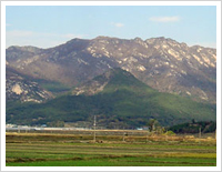
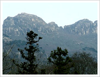
Heukseoksan (Mt. Heukseok)
Image of Heukseoksan in rainy days is changed to black color. Such name seems to be derived from the saying that color of this mountain is black. A ridge extending from Heukseoksan to Gahaksan (577m)-Byeolmaesan (465m) is a mountain range being surged by Wolchoolsan of Youngam to the southwestern side. Main ridge provides a boundary between Haksan-myeon of Youngam-gun and Gyegok-myeon of Haenam-gun.
Scenery of rocky ridge outshining Gongryong ridge of Mt. Seolak and ridge range just like a branch of Mt. Jiri make everybody shout exclamation of delight but this scenery is not yet widely known as it is outshined by Wolchoolsan of Youngam. But if halo effect of Wolchoolsan that solidly stands up as a master and backdrop of this mountain range should be removed and attention should be detracted to an inherent beauty of this mountain, all the ordinary inland mountains may have to step back to the rear of this mountain with low profile.
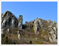
This mountain is called as Byeolmaesan as hodgepodged image of curious rocks is said to look beautiful just like stars in the night sky when watching it from a remote place. Pine trees are strongly rooted in every corner of ridge where solid granite chunk is covered in a row . Even in midwinter, it is a good place for enjoying mountaineering as snowdrift is a rare case. In addition, this mountain is also famous for habitat of orchid with high dignity.
Byeongpoonsan (Mt. Byeongpoong)
Byeongpoongsan (313.1m) was derived from Oriental folding screen of Oknyeotangeum type, a topography of Haenam-eub. If Geumgangsan is a Taoist fairy, Hosan is corresponding to gayageum (Korean traditional string instrument) and Byeongpoongsan is corresponding to folding screen. This mountain embraces Soojeongdong, Geumsoidong and Moonsodong, a birthplace of Sanjoongsingok, a Gosan literature.
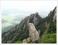
Dalmasan (Mt. Dalma)
Dalmasan is a mountain surged as a long rocky ridge being leaned to the southern side in Haenam-gun. Mountain range being connected to Wando through Dooryoonsan, Daedoonsan and extended to Dakgolje where national highway No. 13 is passing is suddenly changed its image to rocky ridge while crossing mountain ridge like hill.
This rocky ridge spirit being extended for about 8km from the summit (Bulseonbong) where beacon mound is located to Dosolbong (421m) does not die down at all and this spirit finally subsides at Sajabong (155m) surged at Ttanggeut (southernmost tip of Korean peninsula).
Mihwangsa located at the southern side with Dalmasan as its backdrop has a deep relation with this mountain. It is said that in 8th year of King Kyeongdeok during Shilla Dynasty (AD 749) when a ship carrying scriptures and statutes of the Buddha from India arrived at Saja port (current Galdoo port), Euijo, a Buddhist monk, carried this scripture and Buddha statutes on the back of a cow together with his 100 followers but when this cow started to lie down after a big moo on its way, this monk built Tonggyosa on the site where the cow lay and then constructed Mihwangsa at the place where the cow stopped. This means that such temples were endowed and such scripture was enshrined in this mountain by this sacred cow.
Dooryoonsan (Mt. Dooryoon)
This mountain (703m) is located at San 8-1, Goorim-ri, Samsan-myeon, Haenam-gun. As a sacred summit of Haenam, this mountain is well structured with 8 hilly extended summits. Its slope to the northwestern side is gentle and it commands an excellent scenery and as climbing trail is not rough, everybody can arrive at the summit of Garyeonbong within app. 2-3 hours.
This mountain comprises lotus-type mountain shape created by 8 rocky summits. Dooryoonsan comprises 8 summits including Garyeonbong (703m), Dooryoonbong (630m), Gogyebong (638m), Noseungbong (Neungheuhdae 685m), Dosolbong (672m), Hyeolmangbong (379m), Hyangrobong (469m) and Yeonhwabong (613m). These 8 summits have a shape of round circular and its shape represents as if a giant holds his right hand toward the South Sea. If making a shape just like receiving water with concave hand by evenly spreading hand, attaching thumb to index finger and then pulling finger tip, geographical features of Dooryoosan is exactly created.
Dooryoonsan was called as Daedoonsan as well and it was interpreted that 'Han' meaning big was added to 'Deum' meaning a mountain and it was changed as Handeum->Daedeum->Daedoon. That's why Daedoonsa was called as Handeum temple in the past. According to history of Daedoonsa, Dooryoonsan was said to be changed to Dooryoonsan later after it was called as Dooryoonsan by borrowing 'Ryoon' of Chinese Gonryoonsan and the word "Doo" of Baedoosan.
Climbing Dooryoonsan is near to a behavior of leisurely strolling rather than mountain climbing in a way of climbing the summit while properly sweating along the traces of illustrious Buddhist monks. This mountain is a good place to enjoy at any time during four seasons. In early spring, camellia flowers being bloomed in abundance, thick forest and clear valley stream in summer and dazzling autumn leaves in fall are waiting for travellers.
Joojaksan (Mt. Joojak)
As revealed from the name of the mountain, Jujak Mountain was named because its shape appeared like a phoenix flying with widened wings. Spanning from Ohsojae in Samsan-myun, Haenam to the northeast, Jujak Mountain reaches over Bonwhang chun and ends right before Sukmoonsan, Doam-myun, Kangjin. This measures approximately 10km of distance in straight line. The head part of phoenix corresponds to the summit of Jujak Mountain. Its right wing is a chain of rocks stretching to Ohsojae in Haenam while the left wing is a ridge running from north of Soryung in Jakchun all the way to Dukryong Mountain.
The right wing’s rock range is tied with the Jujak Mountain and holds a lot of rock ridges here and there. Standing on the summit of the rock ridges, the archipelago can be viewed by a sight, and also the rock range running parallel with shoreline from northeast to southwest makes me smell the widely open sea and feel a happy climbing.
Entrance of Ohsojae - First rockpeak – 362m Summit – 401.5m Summit – A Colony of Flame Grass – Start of Rock Ridge – 412m summit – 427m summit – Jakchun Soryong (About 4 hours more or less) – Summit of Jujak Mountain (475m) – South Summit of Jakchun Soryong – Jujak Mountain (428m) – Su Yang Resort
Climbing Course: Jujak’s right wing, Ohsojae to Jakchun Soryong Use Time: Ohsojae – Jakchun Soryong: 3 hours 30 minuites – about 4 hours - Ohsojae (Haenam Okchun-Myun to the hill going over Bukil-Myun)
Geumgangsan (Mt. Geumgang)
Keumgang Mountain in Haenam embraces in right Man-Dae Mountain that divides Mengjin-ri and Hwanae-ri of Masan-Myun and in left Man-Dae Mountain that splits Okchun-Myun and Haenam-Eup.
“Man-Dae” stands for ten thousands of big rocks. Big rock is called “Dae” (ground, land) in Chinese character and also Dae may mean to be small peaks (“Bong” in Chinese character) in general.
Conclusively, if Man-“Dae” was interpreted as Man-“Bong”, Keumgang Mountain would be a mountain that holds two “Man-Dae”s (“Man-Bong”s) which means there are twenty thousands of summit in Keumgang Mountain and it has eight thousands more summits than Keumgang Mountain in North Korea that is only twelve thousands of summits.
Below are mountain climber’s favorite courses
Course 1: Hae-Ri - Mae-Bong - Man-Dae Mt. - Keumgang-Jae - Keumgang Mt. - Sangsung Angol - Keumgang Reservoir - Hae-Ri
Course 2: Keumgang-Jae - Heliport - Keumgang Mt. Summit - Keumsam - Keumgang-Gok Reservoir
Course 3: Hae-Ri - Mae-Bong - Man-Dae Mt. - Keumgang-Jae - Keumgang Mt. - Sangsung Angol - Keumgang Reservoir - To Summit 3
Course 4: Keumgang Mt. Reservoir - Sam-Bong - Man-Dae Mt. - Heliport - Keumgang Mt. - Achim-Jae - Hakdong Village
Course 5 : Pal Gak Jung - Miam Rock - ShimTuh - UJong-Bong T-junction - Keumgang Mt. Summit (Both ways of claiming)
Course 6 : Summit 1 - summit 2 - summit 3 - heliport - Man-Dae Mt. Summit (Both ways of claiming)
Course 7:Keumgang Reservoir - Summits 1, 2, 3 (View Rock) - Man-Dae Mt. - Keumgang-Ryong - Keumgang Mt. - Keumgangsansung - Miam Rock - Pal Gak Jung Park - Sungnae Village (5 hours spent)
Galdoosan (Mt. Galdoo)
Name of Galdoosan located at the southernmost tip of Haenam-gun was derived from the saying that since long time ago, kudzu vine was abundantly found in its hillside. Main mountain of Galdoosan being called as Sajabong as well is Dooryoonsan (703m), the highest peak of Haenam-gun. Normal trail route of Daldoosan is a course of Ttangkkeut village (Galdoo port) - former guarding post - threeway intersection - Ttangggut tower - Danggokbi - beacon mound peak - observatory - parking area - village and it takes about 1 hour.
Nowadays, in many cases, travelling by using passenger car is popular but sometimes travellers may climb Galdoosan by taking above route reversely as well. In case of using passenger car, another course is to tour round beacon mound and observatory within 250m distance from wallside trail after climbing up to parking area of main hillside passing the place in front of Green Motel from Galdoo police box.
However, in case of touring round the course leading to Galdoo port through beacon mound - Ttangkkeut bi - Ttangkkeut tower - threeway intersection - former guarding post after parking car at the parking area of main ridge, it will be inconvenient to walk up parking area of main ridge after passing through police box in order to fetch parked car again. And so, it would be convenient to leave the car at the parking area in front of police box or near to control office and walk up parking area of main ridge.